Road Ban In Effect March 28, 2024 at 8:01 AM

Plans and Reports

Corporate Report

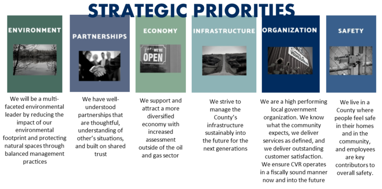
The 2023-24 Corporate Report is intended to be a guiding document to provide direction to CVR departments and their staff as they prepare budgets to reflect the funding and resources required to accomplish the goals of Council. The Corporate Report will be reviewed annually as part of the budgeting process and administration should measure how and when the initiatives are being accomplished.

The plan will be shared with all departments so they understand the goals and objectives; input and ideas then can be provided on what initiatives are realistic to assist in the implementation of the Plan into the day-to-day operations of CVR.

Documents:

2023-24 Corporate Report


Strategic Business Plan Summary 2018-2022

Strategic Plan 2015-2017

Annexation

Annexation is a municipal boundary change to expand for future growth.  In Alberta, annexations are regulated by the Municipal Government Board.  The annexation process involves negotiations between local governments, public engagement with property owners, a formal review by the Municipal Government Board, and ultimately a decision by the Lieutenant Governor in Council.  The entire process is expected to take approximately two years.

The County of Vermilion River will be working with the City of Lloydminster, the RM of Wilton, the RM of Britannia, the Village of Kitscoty and the Town of Vermilion in intermunicipal planning with the aim of enhancing regional cooperation and partnerships.  The benefits of regional co-operation include more goods, services and infrastructure throughout the region.  Enabling urban expansion facilitates successful long-term growth with more economic opportunities, urban services and amenities. Several areas have been identified as more suitable for urban expansion than others.

Lloydminster Annexation

For Regular Updates: City of Lloydminster Annexation website


Intermunicipal Plans

The Municipal Government Act (MGA) links service provision and land use planning: an Intermunicipal Collaboration Framework is not complete unless an Intermunicipal Development Plan has also been adopted by each municipality that shares a boundary with another municipality.  Together, the documents act as a comprehensive strategy for municipalities to work together, be more efficient with their resources, and find opportunities to collaborate.


Intermunicipal Development Plans

What is an Intermunicipal Development Plan (IDP)?

An IDP is a broad-based policy document prepared and adopted by two adjacent municipalities.  The purpose of the plan is for the municipalities to plan and coordinate future land use and development within the boundary area.  In April of 2018, the Government of Alberta mandated that each municipality in the province prepare and adopt an IDP with every municipality with whom they share a boundary.

According to the MGA (Section 631), the IDP must address:

  • The future land use within the area
  • The manner of and the proposals for future development in the area
  • The provision of transportation systems for the area, either generally or specifically
  • The coordination of intermunicipal programs relating to the physical, social, and economic development of the area
  • Environmental matters within the area, either generally or specifically, and
  • Any other matter related to the physical, social, or economic development of the area that the councils consider necessary.

The purpose of the IDP is to establish a regional framework for attracting economic opportunities and managing land use, subdivision and development in the IDP area. The City and County want to improve opportunities to secure a long-term economic base, establish consistency in land development, and to facilitate inter-municipal communication in land development matters. Further, the municipalities want to be “development ready” and future-oriented in their planning efforts and thus acquire an edge over other municipalities in attracting additional economic activity.

This Intermunicipal Development Plan (IDP) is divided into four sections:

  • an introduction containing background information,
  • a detailed explanation of the intent of the IDP concept,
  • a set of specific policies that will guide the Approving Authorities in their decisions
  • a set of implementation statements and directives that will guide the two municipalities in terms of process and policy content.

The Appendices contain support information that is of benefit to applicants for development.

Rural Intermunicipal Development Plans

We are currently working with the Counties of St. Paul, Lac La Biche, Smoky Lake, Two Hills and the MD of Bonnyville on developing Rural IDP's.  


Lloydminster Intermunicipal Development Plan

RFP - County of Vermilion River-City of Lloydminster Intermunicipal Development Plan

IDP Documents: 

Bylaw No. 06-05 Lloydminster Intermunicipal Development Plan (Including 07-03 & 08-17 Amendments)

Area Structure Plans:

Within the IDP, there are three Urban Expansion zones identified, each of which will has a separate Area Structure Plan.

ASP Documents: 

Bylaw No. 07-28 - Central Urban Expansion Area Structure Plan (Including 08-16 Amendments)
Bylaw No. 08-15 - North Urban Expansion Area Structure Plan
Bylaw No. 08-14 - South Urban Expansion Area Structure Plan

Vermilion Intermunicipal Development Plan

The County of Vermilion River and the Town of Vermilion are preparing a new Intermunicipal Development Plan (IDP) pursuant to the Municipal Government Act, R.S.A 2000, c.M-26, as amended.  This IDP will repeal and replace the 2016 IDP adopted by the Town and the County. 

Documents: 

Bylaw 21 18 Vermilion IDP
Bylaw No. 10-11 - North 41 Gateway Area Structure Plan
Bylaw No. 10-15 - Highway 16/41 Crossroads Area Structure Plan


Intermunicipal Collaboration Frameworks

What is an Intermunicipal Collaboration Framework (ICF)?

An Intermunicipal Collaboration Framework (ICF) is a broad-based policy document created by two municipalities that share a boundary.  The purpose of the framework is for the municipalities to plan and coordinate how they could efficiently provide services to their residents within intermunicipal areas.  In April 2018, the Government of Alberta mandated that each municipality in the province prepare and adopt an ICF with every municipality with whom they share a boundary.

The specific purpose of an ICF, as set out in the MGA (Section 708.27):

  • To provide for the integrated and strategic planning, delivery and funding of intermunicipal services
  • To steward scarce resources efficiently in providing local services and
  • To ensure municipalities contribute funding to services that benefit their residents.

CVR is committed to working collaboratively with its urban neighbours when it comes to planning and development. The County is has Intermunicipal Collaboration Frameworks (ICF's) with all of our neighboring municipalities.  These ICF's guide us in planning and coordinating how we efficiently provide services to our residents within intermunicipal areas.

Feel free to contact the County Planning and Community Services Department for further information.

Rural Intermunicipal Collaboration Frameworks

County of Two Hills Intermunicipal Development Plan

County of St.Paul Intermunicipal Development Plan

Village Intermunicipal Collaboration Frameworks

Village of Kitscoty Intermunicipal Development Plan

Village of Paradise Valley Intermunicipal Development Plan

Village of Marwayne Intermunicipal Development Plan

City of Lloydminster Intermunicipal Collaboration Frameworks

RFP - County of Vermilion River-City of Lloydminster Intermunicipal Collaboration Framework

Vermilion Intermunicipal Collaboration Framework

Town of Vermilion Intermunicipal Development Plan

Drainage

Functional Stormwater Drainage - Blackfoot & Devonia Basins (2014)

Sameng Inc. has been retained to complete a detailed functional stormwater drainage plan for both the Blackfoot and Devonia drainage basins as established by Sameng Inc. Blackfoot basin has an area starting at approximately Township Road 510 to the Hamelt of Blackfoot and the Devonia Basin has an area starting south of the Hamlet of Blackfoot to approximately Township Road 492.

The overall goal of the study is to develop a drainage planning strategy throughout the basin that is clearly understood by the public, developers, and the County administration.

Documents:
Blackfoot Basin Concept
Devonia Basin Concept
Summary of Final Report


Functional Stormwater Drainage Plan - Northwest Drainage Basin (2012)

Genivar has been retained to complete a detailed functional stormwater drainage plan for the Northwest Drainage Basin located west of the City of Lloydminster. The extends of the drainage basin are defined by the County of Vermilion River Master Stormwater Management Plan.

The drainage basin covers a total area of approximately 2,725 hectares. The basin is currently agricultural in nature but includes the residential subdivision of Deerfoot Estates, the industrial subdivision of Reinhart, Wist and County Energy Park and the Rolling Greens Golf Course.

The overall goal of the study is to develop a drainage planning strategy throughout the basin that is clearly understood by the public, developers, and the County administration.

Documents:
Executive Summary


Master Stormwater Management Plan (2009)

Recent higher than normal precipitation has resulted in greater flooding in the developed areas and downstream of the developments than was anticipated when the exisitng projects were implemented. The County recognized that a more comprehensive planning process will be needed to improve drainage of exisitng projects and to ensure that future developments do not compound the drainage issues.

Documents:
Master Stormwater Management Plan
Master Stormwater Management Plan Technical Report 

Regional Growth Management Strategy (2013)

The Regional Growth Management Strategy project coincides with the County Municipal Development Plan and Land Use Bylaw Review and will provide recommendations and strategy options for growth within the County. The purpose of the project is to guide the County’s future development in a manner that reflects the vision and aspirations of our residents, landowners, and stakeholders. The RGMS considered economic growth and environmental responsibilities while providing recommendations concerning development within the County of Vermilion River. The Executive Summary shown below outlines the key strategies for Growth in the County of Vermilion River.

Final Report

Vermilion River Regional Alliance (VRRA)

PURPOSE OF THE VRRA

To bring the nine members together to make recommendations to their councils and/or board in the following areas:

  1. Lobby the provincial government on matters of regional concern
  2. Encourage tourism throughout the region
  3. Pursue/Promote economic development throughout the region
  4. Facilitate discussion of partnership projects/grants
  5. Coordinate overlapping or mutually shared services
  6. Develop a strategic plan for long-term direction for the region
  7. Partner with other entities to the betterment of the VRRA members

OBJECTIVES

  1. To build strong municipal leadership in the Vermilion River Region
  2. To provide an opportunity to share emerging and best practices in the Vermilion River Region, while bringing awareness to the potential of shared initiatives
  3. To strengthen regional working relationships
  4. Be a collective voice to provincial and federal governments on regional issues